Wednesday, 5 December 2012
Thursday, 22 November 2012
Poundbury Hillfort
 |
| Poundbury - rampart, looking North |
 |
| Southern rampart with B/A barrow to right |
Originally a univallete enclosure, a second was added and both were revetted in timber. In the later Iron Age this was upgraded to stone. Roundhouses were excavated in the Eastern sector and some of the storage pits also. Looking from the Northern rampart is is obvious that this side of the hillfort is protected by the very marshy ground and the river Frome just below. Taking into account climate change, this would be very much as it was in the Iron Age, but in dryer times this land would have been very fertile, with access to water from the river.
 |
| Southern rampart looking East |

In the modern era Napoleonic soldiers were held here and Brunel tried to push through his railway line, which would have finished off the destruction of half of the hillfort begun by the Romano-British. However, the formation of the Dorset Natural History and Archaeology Society saved the site and forced Brunel to build a tunnel!
In World War I a POW camp was set up here, the off-spring of the Napoleonic camp one hundred years earlier, and in WWII the Observer Corp dug a bunker next to the site and also had a camp.
When walking ones dog on a sunny day, as it was on our visit, it is remarkable that this part of Dorchester has been used in various ways for over two thousand years.
Monday, 29 October 2012
Prittlewell: 'The King of Bling'
Southend-on-Sea is the largest town in Essex and Prittlewell is an ancient settlement that has now been swallowed up by it. It became famous in its own right in 2003 when diggers from Museum of London Archaeology found the most important site of the last 70 years, due to a road widening scheme. I gave this weeks talk on the site.
The site had been excavated in the 1920s when the rail and road workers uncovered a Saxon cemetery:
 In this instance what was uncovered was of greater importance than anyone could have thought possible. The remains of an undisturbed tomb from the 7th century AD:
 The tomb was 4m square, the largest found in the UK, and one of the first finds was the copper bowl hanging from its peg (the top right hand of this photo). Around 110 objects were lifted over a period of ten days.
These gold crosses were an indication that this person was Christian but still buried in a pagan way:

A unique find was this folding stool, seen in manuscripts but never in reality until this site uncovered an example:
 This plain but beautiful gold belt buckle is similar to the more ornate example from Sutton Hoo:
 A startling survival is the remains of a lyre, the most complete example found from this period in the UK:


The quality of the artefacts, both local and imported, make this the tomb of a great noble or even a king. The candidates for his being a king are Saebert (died 616 AD) or Sigeberht II 'The Good' (murdered 653 AD). The dates of the finds indicate that the latter is more likely.
The site had been excavated in the 1920s when the rail and road workers uncovered a Saxon cemetery:


These gold crosses were an indication that this person was Christian but still buried in a pagan way:


The most stunning finds, in my opinion, are the blue glass beakers, which give us an insight into the craftsmanship of Anglo-Saxon glass makers at this time:

Tuesday, 23 October 2012
Dorset Diggers II

On Saturday the Dorset Diggers met at Maiden Newton to have a look at the structure. Although it is on the early 20th century map it could have been reused during WWII after all. It has a mixture of brick types (19th & 20th century) and what looks like a stone doorstep:

The wall nearest the group has an aperture in it which has been roughly brick up; so its original purpose could not have been a water trough. So, this is well worth looking at.
We then went to the cafe to discuss setting ourselves up as a constituted group so that we can look at fund raising, for various bits of equipment etc. Now we need to write up desk top and risk assessments as well as doing some more research generally. Hopefully we can begin excavation sometime in the New Year.
Wednesday, 17 October 2012
Silbury Hill
.jpg) |
| Silbury Hill |
It is around 4,750 years old and has been knocked about so much that it was in danger of falling into itself until English Heritage undertook some conservation a couple of years ago. This was due to a vertical shaft being dug into it in 1776 and a horizontal one in the mid 1800s. Then Flinders Petrie had a go in the early 20th century. Silbury Hill was starting to turn into a Swiss cheese.
The EH work allowed some archaeological investigations to take place; so every cloud has its silver lining. Dr Jim Leary found that the earlier interpretation by RJC Atkinson, that SH had three phases of construction, was wrong by a factor of 20 or more.
 |
| Three phases? |
The mound we see today is 40m high and covers an area of 2 ha. It is estimated that it would have taken 18 million work-hours to shift 248,000 cubic meters of chalk and earth.
In many cultures it is the process of construction that is important, not the final outcome. Also the location is important. The hills position is associated with water, being near the Swallowhead spring of the River Kennet.
 |
| The Swallowhead |
One of the most startling discoveries during the survey of the surrounding land was a large Roman settlement, covering 24 football pitches. Many mounds have Roman burials in them and they may have seen this gigantic mound as sacred themselves.
Another amazing discovery is that of a letter written by Edward Drax, who oversaw the Cornish miners digging in 1776. It was found in 2010 in the British Library. He had found a cavity, 12m deep and 15cm wide and stated that "we have already followed it about 20 feet and we can plumb it above 12 feet more". Drax interpreted this cavity as "something now perished must have remained in this hole to keep it open". David Dawson, director of the Wiltshire Heritage Museum, said: "It tells us that in one of its earliest phases some kind of totem pole was erected on the mound then subsequently additions to build up the hill were piled around that timber".
SH attracts many people, to see one of the most remarkable monuments in Europe. But this can also be a problem. Two people abseiled down the cavity that opened up due to erosion, thus not only putting their lives at risk, and others that may have had to rescue them, but added to the destruction of the monuments by doing so.

Such a reckless act of vandalism shows us that we must protect our irreplaceable heritage at all times.

Thursday, 11 October 2012
Maiden Newton Archaeology
Visited the Dorchester History Centre and had a look at the 1902, 1830 and 1777 maps. The WWII structure is on the 1902 map! So, a Victorian feature, probably agricultural. But we still don't know what its function was. More later.
Sunday, 30 September 2012
Dorset Diggers I
The new archaeology group for Dorset. Dorset Diggers will work in the community promoting Dorset archaeology and undertaking community excavations. Our first project is in Maiden Newton, looking at a World War Two site. What is it? We need to put it back on the map of monuments from this important period in our history. What will we find as we dig down? Keep looking in to find out!

The brick structure at the front of the feature. The bricks go quite deep.
 |
| The structure runs into the hedge and is framed by brick and stone. A mound is quite pronounced. |
Archaeotreks
Please contact me directly for details of Archaeotreks weekends.
07768695162 or tripp.chris60@gmail.com
Thanks.
07768695162 or tripp.chris60@gmail.com
Thanks.
Friday, 21 September 2012
Beaminster
The Site Stories course for Beaminster now starts on the 11th October at the museum, 7pm. Please contact me to go on the list.
tripp.chris60@gmail.com
tripp.chris60@gmail.com
Tuesday, 18 September 2012
Wetwang Slack
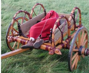
As part of my course at Bridport I gave a talk on the chariot burials at Wetwang in Yorkshire. The excavations of 1984 and 2001 allowed archaeologists to reconstruct an Iron Age chariot and tackle some of the practical engineering problems of how to make one work as an instrument of war and part of burial ritual. The most remarkable discovery is that the fighting platform was free to move by suspending it from the side arches using straps, as can been seen in this photo. Thus the standing warrior, pulled by two ponies driven by a seated companion, would not be thrown off going over rough ground and thus deliver the spear into an enemy.

One grave was that of a woman, c.35-45. This individual was reconstructed and found to have a facial disfigurement. She also had a dislocated shoulder which had not been reset in life. Are the two connected, being on the same side - an accident? Or was this a result of disease or from birth?
The 1984 site was only saved from total destruction by the quarry manager Mr Mick Ward, who stopped the machines when he saw one of the metal tyres sticking out of the side of a cut. He had seen something similar in 1971 and knew what it was. He was posthumously given the BP award for the best non-archaeologist who found and reported archaeology in 1986. It was presented to his son.
Monday, 27 August 2012
The Treasurer's House, Martock, Somerset
This bank holiday I visited a National Trust property called The Treasurer's House. The oldest building was from the early 13th c. The ground floor was for storage and the upper floor for living, including a communal hall and a private bedroom, or solar, with access to a garderobe block with latrine and clothes storage. The smell supposed to have kept out the bugs!


If you are in Somerset it is well worth a visit, but it is only open Sunday, Monday & Tuesday during summer. It is a pity that more archaeology is not being done in the surrounding grounds, as I am sure it would add more to the story of the people who lived here.

In this early structure is found a nice surviving fresco, in the solar, of the Crucifixion.

By 1300 the Great Hall had been built and was a place of assembly separate from the private residence.

 |
| The main hall |
By 1500 the garderobe had gone and was replaced by a kitchen. The ground floor of the solar was now a parlour with a door to the kitchen. There was probably a gallery for musicians or spectators at meetings in the main hall. By the 17th c. the gallery had been covered and converted into rooms.

 |
| The house today |
Wednesday, 22 August 2012
Bridport & Beaminster classes
Just a reminder for those looking in that my classes start on the 9th and 12th September.


Tuesday, 21 August 2012
Ham Hill tour
Thanks to Hayley Roberts for showing us around the excavations at Ham Hill this past Sunday morning.
I had the wrong entrance, as the site is away from the main car park to the hillfort/country park area. I had to drive to where I had directed the students and herd them to the right place!
Once there Hayley gave an introduction to the work being carried out. The main focus is a large open area focused on trackways and enclosure ditches, some dating from the Bronze Age but mostly Iron Age. Some roundhouses and burials have also been found.


We then had a look at the smaller trenches being cut across the ramparts.
One of the trenches through the ramparts had unearthed some in situ pottery.

Most exciting for me was meeting Nail Sharples, who dug Maiden Castle in the '80s. This was a rare chance to see a hillfort under excavation and everyone was grateful to Hayley for taking us around.
I had the wrong entrance, as the site is away from the main car park to the hillfort/country park area. I had to drive to where I had directed the students and herd them to the right place!
Once there Hayley gave an introduction to the work being carried out. The main focus is a large open area focused on trackways and enclosure ditches, some dating from the Bronze Age but mostly Iron Age. Some roundhouses and burials have also been found.

She then showed us some finds.

Which included:
 |
| A nice example of Glastonbury Ware |
and:
 |
| A Roman ballista bolt |
 |

Most exciting for me was meeting Nail Sharples, who dug Maiden Castle in the '80s. This was a rare chance to see a hillfort under excavation and everyone was grateful to Hayley for taking us around.
Wednesday, 15 August 2012
Ham Hill Map

For all those that are coming to Ham Hill this Sunday here is a map. Yeovil is to the right and the blue P is where you are aiming for. There are signs from Yeovil. I'll be around wearing a hi-viz vest. See you there at 10.45am.
Thursday, 9 August 2012
Archaeology Courses

I have two courses starting in September: one at Bridport on the 9th at the Quakers Meeting House, South Street and the other at Beaminster Museum on the 12th. Both are in the evening 7-9pm. £80 for ten sessions including two site tours and refreshments. The course is called Site Stories and will be about some of the best and most famous sites excavated in England.
Contact: 0776 869 51 62
Tuesday, 7 August 2012
Walks - 11th & 18th August
 |
| Durngate Forum |
Hope to see you there.
Ayia Triada
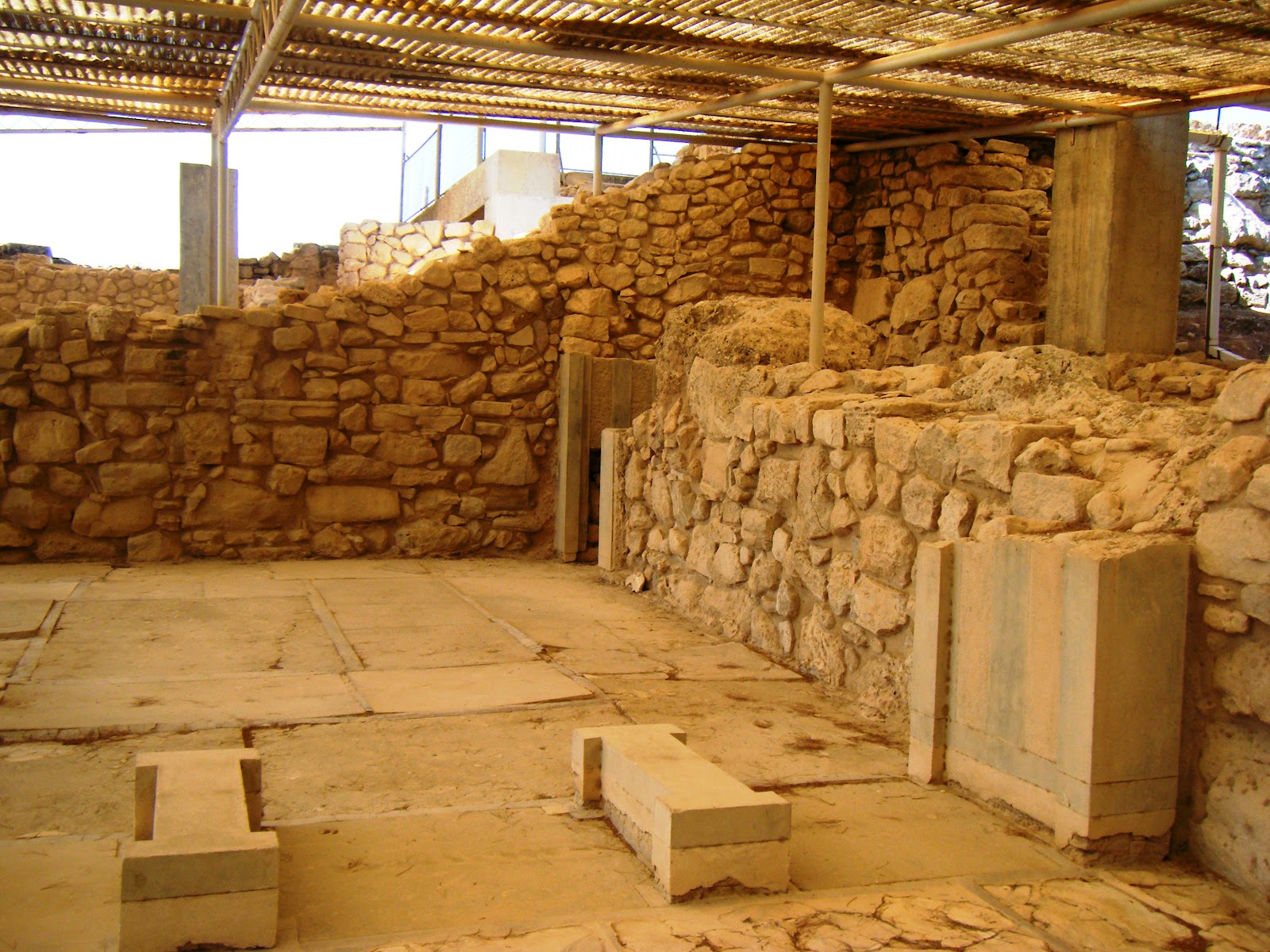
The royal villa of Ayia Triada was erected in the New Palace period c. 1600 BC and was destroyed at the end of the 15th c. BC. It was decorated in palatial luxury, with gypsum facing slabs, painted floors and wall paintings. It is in the shape of an irregular L.

The ruler's quarters are in the north-west corner of the complex and comprise of the main hall, a portico and light-well, a room with a 'bench' and a revetment of gypsum slabs and a peristyle courtyard with fine views.


The ruler's quarters are in the north-west corner of the complex and comprise of the main hall, a portico and light-well, a room with a 'bench' and a revetment of gypsum slabs and a peristyle courtyard with fine views.


The Minoan settlement, the 'village' of the New Palace (17th-15th c. BC) and Post-Palace (14th-13th c. BC) periods lies to the north of the villa. The 'agora' was erected in the square on the east side of it and was a large complex of eight storerooms or shops, fronted by a long rectangular portico with columns and pilasters.

Later, sanctuaries were built in the Protogeometric and Geometric periods and the sanctuary of Zeus Velchanos functioned in the Hellenistic period. There are also sporadic finds from Roman and Venetian-Turkish times.
Whilst there I chatted with the Italian director of the small dig taking place this year and he showed me around the site and some of the finds.
 |
| Tools of the trade |
 |
| Artefacts |
 |
| Some fine stonework |
Special mention should be made of the unique stone sarcophagus, painted with composite scenes showing the cult of the dead.

Tuesday, 31 July 2012
Phaistos
I revisited the Minoan site of Phaistos, as I was last here in 2001, and came away with a better understanding of the site. The old palace complex is established and this is the flight of steps ending at a later wall ('we're on the [stairs] to nowhere' - Talking Heads) with a raised walkway leading to it.

Just to the south are large circular structures that were possibly silos for the storage of grain.

The later west 'propylaea' is very impressive and consists of a landing, a porch with a central column, a portico and a light well.

The north wing includes the complex of the 'royal apartments'.

The official character of these rooms is emphasised by the monumental facade of the wing facing the main gate and with painted niches to either side for the guards posted at the gate, which is flanked by half columns.

The main court preserves its paving, dating from the Protopalatial period (1900-1700 BC).

Two rooms are off especially luxurious construction, with walls revetted with alabaster, paving slabs, wall-paintings and flanked by light-wells, balconies and a large peristyle courtyard.
Next blog post is on Ayia Triada, where I bump into some fellow archaeologists.
Subscribe to:
Posts (Atom)